eRoutes – Ride Real Roads Indoors | Ride Cave

Browse eRoutes

Explore real-world GPS eRoutes from the Ride Cave community. Upload your own or ride one today.

eRoutes

Everything you need to ride the world indoors

Riding an eRoute inside the Infinite World, a sunny coastal desert road
🏞️

The Infinite World

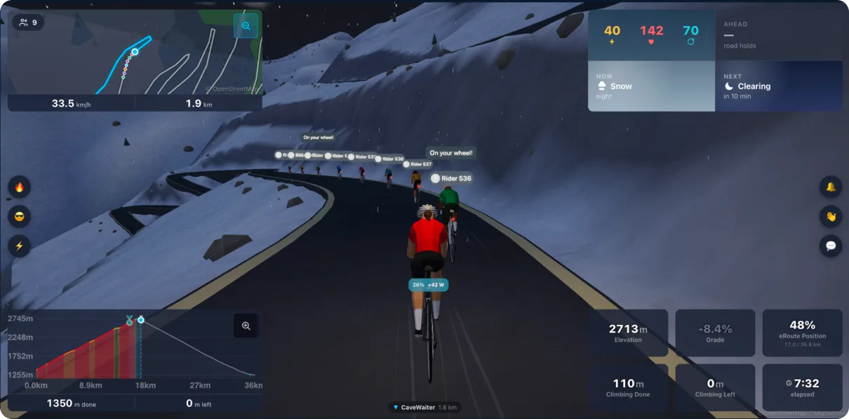
Ride the route inside a living 3D world built from its real terrain: day rolls into night, weather moves through, and other riders on the route appear live on the road beside you. Draft their wheel, form a peloton, ring a cowbell. Free preview on official routes; every route with Cave Crew.

✏️

Ride Anywhere

No file? Draw one. Tap the pencil on the eRoutes map, drop a few points anywhere on Earth, and generate a rideable route on real roads with real elevation.

📁

GPX, TCX & FIT support

Upload any file from your GPS device, cycling computer, or fitness app. Drag and drop or use the upload button; files up to 50 MB are supported.

📐

Grade simulation

Your trainer adjusts resistance in real time to match the road gradient. Climbs get harder, descents get easier, just like riding the real thing.

✂️

Trim before you save

Drag trim handles on the elevation chart to cut the start or end of any route. Distance, elevation gain, and estimated duration update live as you drag.

🗺️

Live 2D map

Track your position on a live vector map as you ride. The completed portion glows bright; what's ahead is dimmed. Hover the elevation chart to scout any point on the map.

🛰️

3D satellite fly-through

A 3D satellite camera pitches at 65° and rotates to face the direction of travel as you ride. Real terrain relief is applied, so mountains look like mountains.

👥

Community library

Share routes with the community or keep them private. Star favourites, clone routes from other riders, and browse a growing library of real-world rides.

Live panels

See where you are, every pedal stroke

Three dedicated panels update continuously as you ride. Toggle between a full-route view and a zoomed follow-rider mode on both the elevation chart and the map.

📈

Colour-coded elevation profile

The elevation chart colours each segment by grade: green for flat, yellow for moderate, orange for steep, red for very steep. A pulsing dot marks your current position. Tap the zoom button to follow your rider through a 20% window of the route with a miniature overview inset in the corner.

🌍

2D map & 3D fly-through

The 2D map panel uses your chosen map theme and tracks your position with sub-second precision, interpolated between GPS points. Switch to the 3D fly-through for a satellite view with real terrain: the camera smoothly rotates to face the direction of travel and follows you through every turn.

Data & widgets

Seven new live data fields

eRoute data fields work in the widget formula builder alongside every other metric. Build custom tiles, set colour thresholds, and display exactly what you want during your ride.

📉

eRoute Grade

Current road gradient in %. Use the alias grade or gradient in any formula.

⛰️

eRoute Elevation

Current elevation interpolated from the GPS track in metres. Updates continuously as you climb and descend.

📍

eRoute Position

Your position along the route as a percentage, 0-100. Combine with a gauge widget for a clean visual indicator.

➡️

Distance Remaining

Metres to the finish. Divide by 1000 in a formula to show kilometres remaining on your dashboard.

🧗

Climbing Remaining

Elevation gain still ahead in metres. Divide by Total Elevation Gain to show what percentage of the climbing is left.

📏

eRoute Total Distance & Elevation Gain

Full route length and total elevation gain for the whole route. Use these as denominators in progress formulas.

Start riding real roads today

eRoutes is free for all Ride Cave users. Upload a GPX, TCX, or FIT file and ride it on your trainer in minutes.